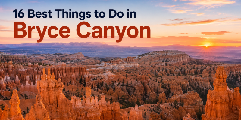
The striking landscape of Bryce Canyon National Park is defined by intense geological processes driven by high altitudes, freezing water, and chemical weathering. Located in southern Utah on the edge of the Paunsaugunt Plateau, Bryce Canyon is not a true canyon formed by a central river, but rather a vast, horseshoe-shaped amphitheater carved straight into the pink limestone cliffs of the Claron Formation.
Reaching elevations above 9,000 feet, the park experiences dramatic daily temperature swings that fuel intense frost-wedging cycles. These forces continuously shatter the rock, carving out the world’s highest concentration of geological pillars known as hoodoos. This structural and geographic brief breaks down the core mechanics of Bryce Canyon’s landscape and outlines the sixteen premier activities optimized for park exploration.
Technical Mechanics: Frost Wedging, Acid Dissolution, and Dark-Sky Physics
Understanding how Bryce Canyon’s geology and atmosphere interact requires breaking down several distinct physical and environmental systems.
                      [ THE HOODOO SCULPTING MATRIX ]
                                     │
         Tectonic Uplift Raises the Colorado Plateau Matrix
                                     │
         ┌───────────────────────────┴───────────────────────────┐
         ▼                                                       ▼
┌─────────────────────────────────┐                     ┌─────────────────────────────────┐
│     FROST-WEDGING FREEZE CYCLES │                     │   CARBONIC ACID DISSOLUTION     │
│ Water enters vertical joints;   │                     │ Weakly acidic rainwater melts   │
│ expands 9% upon freezing to     │                     │ the soft limestone layers,      │
│ fracture rock into open fins.   │                     │ leaving harder caprocks intact. │
└────────────────┬────────────────┘                     └────────────────┬────────────────┘
                 │                                                       │
                 ▼                                                       ▼
┌─────────────────────────────────────────────────────────────────────────────────────────┐
│                           ATMOSPHERIC PURITY PROFILE                                    │
│ - High elevation (9,000+ ft) clean air maximizes baseline astronomical tracking.        │
│ - Certified International Dark Sky status protects exceptional cosmos visibility.       │
│ - Low local light pollution reveals clear, detailed views of the Milky Way galaxy.      │
└─────────────────────────────────────────────────────────────────────────────────────────┘
1. The Physics of Frost Wedging
The primary force shaping Bryce Canyon is frost wedging, a physical weathering process driven by the region’s high altitude and regular freezing cycles. The park experiences roughly 200 freeze-thaw cycles each year. During the day, melting snow and ice seep into vertical fractures and joints in the limestone cliffs. Overnight, temperatures drop below freezing, causing the trapped water to freeze and expand by 9% in volume. This expansion exerts incredible pressure on the surrounding stone, widening the cracks and shattering the rock to form thin walls called “fins.”
2. Chemical Rainwater Dissolution and Differential Erosion
While frost wedging breaks the rock into vertical slices, chemical weathering shapes them into distinct pillars. As rain falls through the atmosphere, it absorbs carbon dioxide, forming a weakly acidic solution called carbonic acid. This mildly acidic water slowly dissolves the calcium carbonate matrix holding the limestone layers together. Because the Claron Formation features alternating layers of soft shale, mudstone, and harder magnesium-rich limestone, the softer rock wears away much faster. This uneven erosion leaves protective “caprocks” sitting on top of narrower pillars, giving the hoodoos their signature totem-like shapes.
3. Atmospheric Clearness and Dark-Sky Mechanics
Beyond its geological marvels, Bryce Canyon possesses unique atmospheric qualities due to its high altitude and remote location. Sitting far above dense sea-level moisture and major city grid light pollution, the park offers exceptional air clarity and exceptionally low light pollution levels. This pristine environment earned the park an official International Dark Sky certification in 2019, creating a perfect window for astronomical viewing where stargazers can see the detailed structures of the Milky Way galaxy spanning across the night sky.

The Bryce Canyon Activity & Trail Matrix
This reference index lists the sixteen premier activities, trail parameters, and difficulty profiles optimized for navigating Bryce Canyon’s high-altitude terrain.
| Activity Node | Physical Trail Length | Difficulty Rating | Primary Geological / Atmospheric Feature | Key Safety Advisory |
| 1. Queen’s Garden & Navajo Loop | 2.9 Miles (Combined Loop) | Moderate | Connects Sunrise and Sunset Points; features Queen Victoria hoodoo. | Steep switchbacks; loose gravel requires high-traction hiking boots. |
| 2. Horseback Amphitheater Ride | 5-Mile Dedicated Track | Moderate | Guided trail rides descending into Peekaboo Loop canyons. | Late-spring to mid-autumn only; follow all wrangler commands. |
| 3. Southern Scenic Highway Drive | 18-Mile Paved Corridor | Low Exertion | Climbs to 9,115 feet; accesses four major amphitheater viewpoints. | Use designated pullouts; watch for wildlife crossing the high plateau. |
| 4. National Park Visitor Center | N/A (Indoor Hub) | Low Exertion | Features A Song of Seasons film, tactile maps, and museum exhibits. | Best starting point for weather alerts and ranger-led itinerary adjustments. |
| 5. Lodge Restaurant Dining | N/A (Historic Lodge) | Low Exertion | Serves hot elk chili and canyon fries inside the grand dining hall. | The only formal in-park lodging asset; reservations highly recommended. |
| 6. July Geology Festival | Variable Guided Paths | Low to Moderate | Educational weekend events breaking down Claron Formation layers. | Great option for families; features evening outdoor ranger stories. |
| 7. The Grand Staircase Trek | ~100 Miles (Backcountry) | Extreme | Vast, multi-park sedimentary network tracing 600 million years of history. | Requires advanced wilderness camping permits and water filtration setups. |
| 8. Ranger Certification Programs | Variable Activity Tasks | Low Exertion | Interactive junior ranger booklets and guided rim-walk geology talks. | Free with park entry; snowshoe hikes require prior reservations. |
| 9. Night Sky Telescope Viewing | N/A (Visitor Center Hub) | Low Exertion | High-visibility stargazing spot; view thousands of stars over the plateau. | Bring a heavy insulated jacket; temperatures drop rapidly after dusk. |
| 10. Christmas Bird Counting | Variable Trail Networks | Moderate | Citizen science project monitoring nearly 100 winter avian species. | Dress in multi-tier winter gear; paths are frequently covered in thick ice. |
| 11. Mossy Cave Trail Hike | 0.8 Miles (Round-Trip) | Easy | Traces the Tropic Ditch stream past a small waterfall and moss cavern. | Accessible family route; stay off steep slopes to avoid rockfalls. |
| 12. The Comprehensive Rim Trail | 5.5 Miles (One-Way) | Easy to Moderate | Paved, flat paths connecting major viewpoints across the rim edge. | Zero shade canopy; carry ample drinking water to manage high altitude. |
| 13. Peekaboo Loop Slot Canyon | 5.5 Miles (Full Loop) | Strenuous | Tight, winding rock narrows that mimic classic desert slot formations. | Shares paths with horse tours; step aside safely to let stock pass. |
| 14. Rainbow Point Overlook | 1-Mile Loop Connection | Low Exertion | Highest elevation viewpoint (9,115 ft); accesses ancient Bristlecone Pines. | Noticeably colder than lower points; pack extra layers year-round. |
| 15. Winter Hoodoo Snowshoeing | Variable Rim Sections | Moderate | Ranger-led winter treks over pristine snow fields blanketed in white. | Snowshoe rentals available at Visitor Center; advance booking required. |
| 16. Tropic & Cannonville Transit | Regional Road Network | Low Exertion | Drives past local farmlands, jagged cliffs, and rural town coffee houses. | Excellent golden-hour photography route outside the main gate boundaries. |
Architectural Breakdown of Key Exploration Zones
                        [ THE CANYON LANDSCAPES ]
                                    │
         Balances steep, winding trail descents with flat plateau rim walks
                                    │
       ┌────────────────────────────┼────────────────────────────┐
       ▼                            ▼                            ▼
┌──────────────────┐         ┌──────────────────┐         ┌──────────────────┐
│  THE INNER BASIN │         │  THE PLATEAU RIM │         │ THE NORTH RIFT   │
│ - Navajo Loop    │         │ - Sunrise Point  │         │ - Mossy Cave     │
│   Wall Switching │         │   Dawn Shifts    │         │   Desert Stream  │
│ - Peekaboo Trail │         │ - Rainbow Point  │         │ - Tropic Ditch   │
│   Slot Narrows   │         │   Ancient Pines  │         │   Waterfall Path │
└──────────────────┘         └──────────────────┘         └──────────────────┘
1. The Deep Amphitheater Descents: Queen’s Garden & Navajo Loop
Descending below the rim into the heart of the Bryce Amphitheater provides an intimate look at the scales of physical erosion. Combining the Queen’s Garden and Navajo Loop trails into a single 2.9-mile loop takes hikers past iconic rock pillars like the Queen Victoria hoodoo before dropping down into the towering limestone walls of Wall Street. Navigating these narrow switchbacks requires good physical conditioning and durable footwear to handle the loose, shifting gravel slopes safely.
2. The High-Elevation Panoramic Overlooks: Rainbow Point & The Rim Trail
For visitors looking to experience panoramic vistas of Utah’s unique geology without a strenuous descent into the canyon, the park’s 5.5-mile Rim Trail provides flat, paved walkways that link the main overlooks, including Sunrise, Sunset, Inspiration, and Bryce Points. Driving all the way south along the scenic route leads to Rainbow Point, the highest point in the park at 9,115 feet. This high overlook offers an expansive view of the entire Grand Staircase landscape, showing off the colorful bands of sedimentary rock layers that reveal millions of years of Earth’s history.
3. The Hydro-Irrigation Corridors: Mossy Cave Trail
Located along the northern boundary of the park, the Mossy Cave Trail offers a distinct, water-filled environment that contrasts with the typical dry desert landscape of southern Utah. Following the Tropic Ditch—an irrigation channel carved by Mormon pioneers in the late 19th century—this easy 0.8-mile trail leads hikers past red rock cliffs, a small spring waterfall, and a shaded alcove filled with thick moss. In the winter months, water dripping from the cave ceiling freezes into massive ice pillars, offering a completely different look from the summer wildflower displays.

Technical Safety and Environmental Protection Protocols
To safely navigate high-altitude desert environments, protect fragile geological features, and ensure an eco-conscious visit, park visitors must strictly enforce these safety steps:
Conclusion
The comprehensive scientific and geographic assessment of Bryce Canyon National Park confirms that this unique landscape is a masterpiece of volatile environmental forces. By balancing the continuous physical impacts of winter frost wedging with the delicate chemical dissolving of rainwater, the park maintains an ever-changing collection of striking limestone pillars that continue to draw outdoor enthusiasts year-round.
As seasonal travel patterns shift and modern national park management emphasizes sustainable visitor guidelines, the core strategy for successful exploration remains clear. Combining careful logistics preparation with a deep respect for the park’s fragile geology and high-altitude micro-climates ensures that every journey through these iconic hoodoos unfolds with absolute safety, educational depth, and flawless execution.