The Greek island of Milos has rapidly ascended from a quiet Aegean outpost to a premium global travel destination, driven largely by its otherworldly volcanic topography. Unlike the heavily commercialized sands of Mykonos or Santorini, Milos offers a diverse hydrological and geological portfolio that caters to adventure tourism, luxury travel, and secluded exploration. As documented in recent luxury travel syndications, navigating these distinct coastal environments requires strategic planning. This intelligence brief deconstructs the geological mechanics, optimal deployment strategies, and transit friction of the top beaches on Milos Island.
Technical Mechanics: Geological Assets & Hydrological Profiles
The primary draw of Milos is not standardized sandy beaches, but rather highly specialized micro-environments dictated by ancient volcanic activity.
-
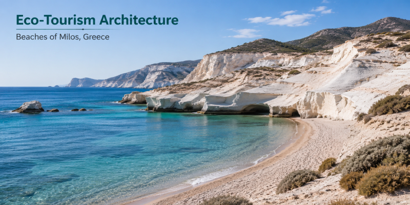
The Sarakiniko Moonscape: The most iconic asset on the island, Sarakiniko, is not technically a beach but a massive, undulating formation of bone-white volcanic rock (pumice and ash) smoothed by wind and wave erosion. It functions as a high-yield photography location and a prime cliff-jumping site when the Aegean currents are calm. The stark contrast between the white rock and the deep blue water creates a visual aesthetic highly optimized for platforms like Instagram, driving significant organic tourism to the island.
-
Geothermal Dynamics: Paralia Paleochori Beach leverages active underwater geothermal vents. This localized volcanic activity physically heats the sand and the shallow waters. Local hospitality architecture, such as the Sirocco Volcanic Restaurant, exploits this feature by burying and cooking fresh seafood directly in the heated sand, providing an experiential dining element unique to this specific coastline.
-
The Kleftiko Pirate Caves: Kleftiko Bay is defined by towering white limestone stacks and a complex network of sea caves, historically used as pirate hideouts. Because it lacks a traditional sandy shore, engagement requires either an extended hike down the cliff face (detailed on AllTrails) or direct aquatic access via chartered boat, filtering out casual tourists and maintaining a high-value, secluded experience.
Strategic Deployment Matrix
Structuring a comprehensive itinerary for Milos requires matching the operational profile of each beach to the specific logistical capabilities and desires of the traveler.
| Coastal Asset | Tactical Geographic Profile | Strategic Utility & Engagement Model |
| Sarakiniko Beach | Northern Volcanic Coast | Iconic photography, sunset viewing, and advanced cliff-jumping. |
| Kleftiko Bay | Southwestern Cliffs | Adventure hiking, private boat charting, and cave exploration. |
| Fyriplaka Beach | Southern Sandy Bay | Full-day leisure deployment with established infrastructure (sunbeds, beach bars, kayak rentals). |
| Kolympisionas Beach | Eastern Unpaved Coast | Absolute seclusion and privacy (skinny-dipping), requiring off-road vehicle capabilities. |
| Mandrakia / Firopotamos | Northern Fishing Villages | Cultural immersion, waterfront dining (Medusa restaurant), and swimming off historic docks. |
| Paralia Paleochori | Southern Volcanic Coast | Geothermal swimming and experiential volcanic-sand dining. |

Structural Vulnerabilities and Systemic Limitations
-
Transit Friction and Infrastructure Limits: The primary structural vulnerability of Milos is its rugged, underdeveloped interior. Accessing secluded coves like Kolympisionas or Agkali (near the Milos Cove Hotel) requires navigating severe, unpaved dirt roads. Standard economy rental cars are frequently insufficient, necessitating the higher expense of an SUV or ATV. Travelers must account for this transit friction when budgeting both time and capital.
-
Marine Weather Volatility: Access to key sites like Kalamos Beach (boat-only) and the cliff-jumping ledges of Sarakiniko are entirely dependent on Aegean wind patterns. The Meltemi winds, which peak in the summer, can create rough, highly dangerous sea conditions, frequently forcing the cancellation of boat charters and rendering exposed beaches unswimmable. Real-time monitoring of maritime weather conditions via platforms like Windy is essential.
-
Capacity Overload at Heritage Sites: Picturesque fishing villages like Mandrakia and Firopotamos operate on very limited spatial footprints. As the island’s popularity surges, the traditional waterfront houses (syrmata) and narrow docks struggle to support heavy tourist foot traffic, leading to rapid sell-outs of accommodations and extensive wait times at iconic local restaurants during peak season.
Conclusion
The strategic verdict on Milos is that it offers one of the highest-yield coastal experiences in Europe, provided the traveler is willing to navigate its rugged logistical constraints. By recognizing that the island’s primary assets—from the moonscapes of Sarakiniko to the geothermal sands of Paleochori—are dictated by aggressive geological realities, visitors can engineer a highly customized itinerary. Success on Milos requires moving beyond the standard beach-lounging model and embracing off-road navigation, private boat chartering, and a deep respect for the volatile maritime environment of the Aegean Sea.
Also Read :Hospitality Architecture: Strategic Breakdown of Elite Maldives Family Resorts